
Deepwater Horizon
Tracing Macondo Oil Along 1,300 Miles of Gulf Coast Shoreline
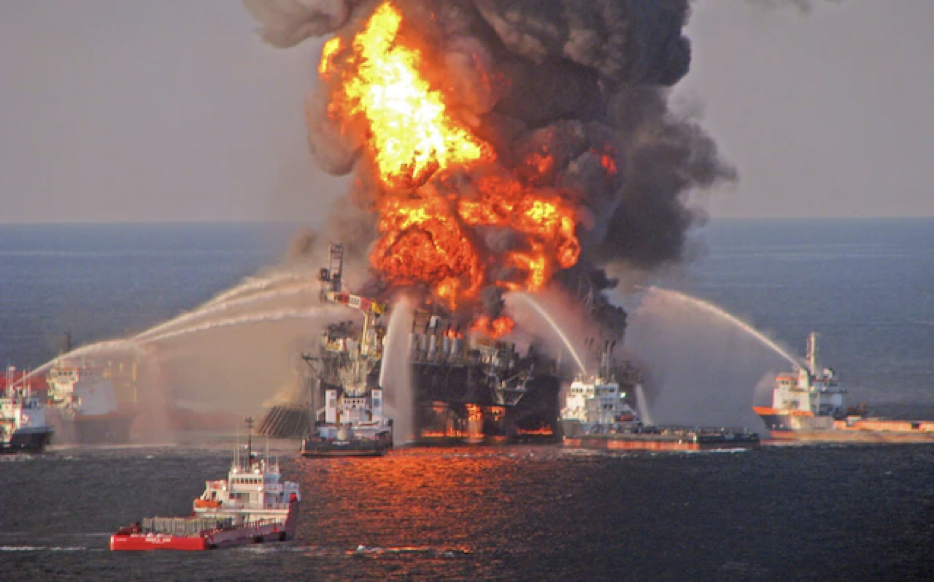
Some contamination events unfold at a scale that makes ordinary site investigation methods feel almost quaint. When the Deepwater Horizon platform exploded in April 2010 and the Macondo well released oil into the Gulf of Mexico for 87 days, the resulting shoreline impact stretched across four states and well over a thousand miles of northern Gulf of Mexico coastline. Sorting out where that oil actually went, how it changed over time, and how confidently a given sample of soil, sediment, or tissue could be tied back to the spill became a forensic chemistry problem of unusual magnitude. NOAA assembled an exceptional team of diverse oil spill experts to tackle this Natural Resource Damage Assessment charged with the collection, analysis, and interpretation of several thousand nearshore samples collected between 2010 and 2012. Dr. Scott Stout spearheaded the forensic sampling and chemistry program for NewFields and pulled me on to help with the nearshore program.
The Scale of the Sampling Effort
The nearshore assessment focused on the shoreline and the waters within about three miles of the coast. It involved more than twenty separate sampling work plans developed by multiple technical working groups. Field teams collected over 5,600 samples across Louisiana, Mississippi, Alabama, and Florida. We collected soils above the tide line, sediments below it, tissue from oysters and other organisms, and material captured on absorbent pom-poms deployed to catch floating oil. Some of these samples came from beaches and marshes where oiling was visible to the naked eye. Others came from submerged areas, oyster reefs, and beds of underwater vegetation where impacts were far less obvious.
A project of this size raises a basic question before any chemistry can proceed: what did the shoreline environment look like before the spill reached it? Several hundred samples collected in the earliest days after the explosion, before oil had reached a given location, served as a pre-oil baseline. That baseline mattered because Gulf Coast sediments are not pristine. At the time, Louisiana alone experienced about 5,000 oil spills annually. Natural oil seeps, decades of vessel traffic, and prior industrial history all leave their own hydrocarbon residues in coastal soils and sediments. Any method for identifying Macondo oil needed to be tested against that ambient backdrop to avoid mistaking older, unrelated hydrocarbons for evidence of the spill.
Chemical Fingerprints in Changing Environments
Identifying Macondo oil in a sample relied on chemical fingerprinting; i.e., using hydrocarbon chemistry (including polycyclic aromatic hydrocarbons and geochemical biomarkers) to compare field samples against reference samples of the oil in both fresh and weathered states (1). This work relied heavily on Dr. Stout careful assessment of changes in the Macondo oil after it left the wellhead, surfaced, and migrated to shore (2). It evaporated as it traveled across the surface of the Gulf, dissolved partially into the water column, and mixed with other hydrocarbons already present in the environment. Once it reached shore or settled into sediment, weathering continued through further evaporation and through microbial breakdown that unfolded over months and years. A sample collected in 2010 and a sample collected from the same general area in 2012 could carry meaningfully different chemical signatures despite tracing back to the same spill.
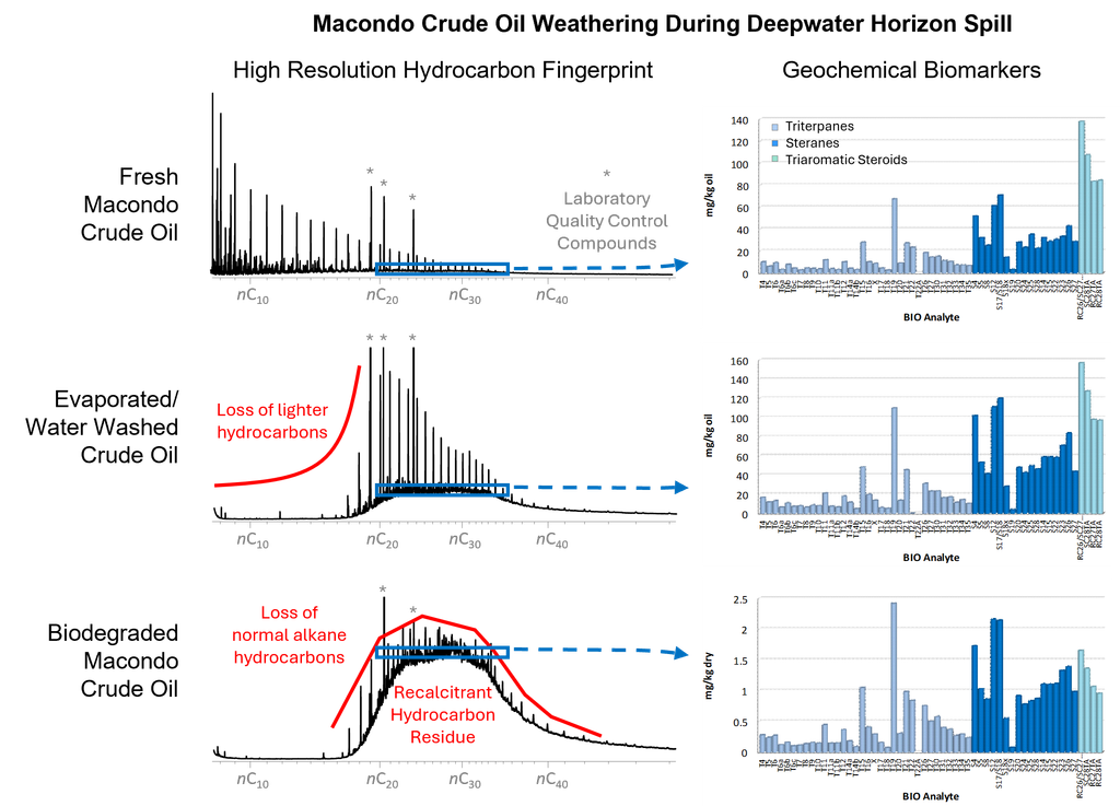
Tracking that transformation turned out to be almost as informative as detecting the oil itself. The degree of weathering in a sample offered a rough sense of how long oil had been present in a given location and whether it had likely come from material still submerged offshore or from oil that had been sitting on the surface or in upland soil for some time. Stranded oil samples showed the heaviest weathering, largely from extended evaporation, while material recovered from submerged sediment tended to show a somewhat different, generally slower pattern.
What the Results Showed, and What They Left Unresolved
Across the full nearshore dataset, roughly a third of samples were classified as containing Macondo oil. That fraction varied considerably by location, by sample type, and by how close a given area sat to the shoreline where oil was known to have stranded. Louisiana carried the highest frequency of detections, consistent with its proximity to the wellhead and the extensive marsh shoreline that took on heavy oiling. Detections in oyster tissue were comparatively rare, a pattern that appeared tied to how quickly oysters process and eliminate hydrocarbons from their tissue rather than to an absence of exposure. Submerged sediment samples collected well after the initial response, including some gathered following storm events in 2011 and 2012, still occasionally carried a Macondo oil signature, illustrating how oil that had settled into subtidal sediment could persist and, on occasion, redistribute long after the wellhead was capped.
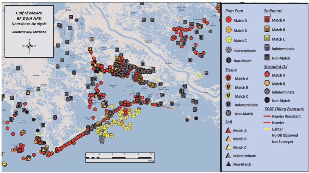
None of this produced a single, tidy answer to “how much oil is left and where.” Instead, it produced a large, structured body of sample-level evidence, organized by location, depth, sampling date, and matrix, that could support more specific questions about particular habitats, particular species, or particular stretches of coastline. Forensic chemistry did not resolve every question about the spill’s ultimate ecological consequences, and it was not designed to. What it did was give investigators a defensible basis for saying, sample by sample, whether Macondo oil was present, roughly how weathered it was, and how that pattern fit into the broader geography of the spill.
Lessons Learned
Large-scale contamination events rarely lend themselves to a single test or a single sampling event. This project involved many independent teams, sampling plans, and years of collection. The forensic sampling and chemistry program had to remain consistent across all of it in order to produce results that could be compared meaningfully from one work plan to the next. For legal professionals working on matters involving large or long-running contamination events, a few patterns from this case tend to recur elsewhere. Establishing baseline or background conditions before contamination arrives, when that opportunity exists, can materially strengthen later conclusions about what changed and when.
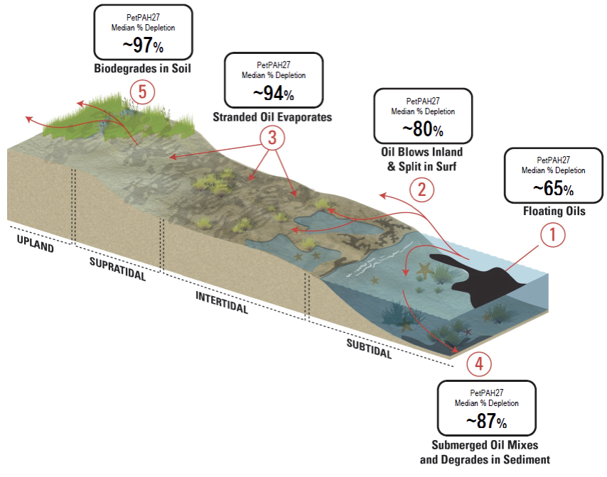
Contamination does not sit still chemically. It weathers, migrates, and mixes with what was already there, and that transformation itself can carry useful information about timing and origin rather than simply obscuring the original signal. Different environmental compartments, whether soil, sediment, or tissue, can show very different pictures of the same event, sometimes for reasons related to biology rather than the extent of contamination itself. A large volume of well-organized sample data, even without a single unifying conclusion, can still provide a solid evidentiary foundation for the more targeted questions that follow in litigation or natural resource damage claims. This body of data continues to instruct forensic investigations broadly in the form of many textbooks, publications, and presentations. An even greater lesson is the healing power of the natural world… Let’s hope we never have to test it again.
- Emsbo-Mattingly, S.D. and C. Martin. (2015) Distribution and Weathering of Macondo Oil in Nearshore Soils, Sediments, and Tissues Collected Between Spring 2010 to Spring 2012 Based on Chemical Fingerprinting Methods. DWH NRDA Chemistry Technical Working Group.
- Stout, S.A., Payne, J.R., Emsbo-Mattingly, S.D., Gregory Baker (2016) “Weathering of field-collected floating and stranded Macondo oils during and shortly after the Deepwater Horizon oil spill.” Marine Pollution Bulletin 105: 7-22. DOI: 10.1016/j.marpolbul.2016.02.044.
- Rouhani, S., Baker, M.C., Steinhoff, M., Zhang, M., Oehrig, J., Zelo, I.J., Emsbo-Mattingly, S.D., Nixon, Z., Willis, J.M., and Hester, M.W. (2017) “Nearshore exposure to Deepwater Horizon oil.” Marine Ecology Progress Series 576: 111-124. doi: 10.3354/meps11811.
Need Source Identification Expertise?
From source identification to litigation support, our team is here to help you move forward with confidence. Contact our specialists today.
Schedule a Consultation